Launch GIS from Assetic
The Assetic System Connector is used to launch a 3rd party GIS using the context of the current page to define the spatial feature to automatically navigate to within the GIS upon launching. Examples of this may be the location of a work request or the location of an asset.
NOTE If you are not familiar with the Assetic System Connector or how it is configured please read the article System Connector before reading this article. Before attempting to configure the System Connector, first attempt to launch the GIS directly from a browser navigation bar to ensure your URL syntax is valid.
Launching GIS
The configuration applied via the System Connector will result in a new action being available when a user is viewing a record in Assetic.
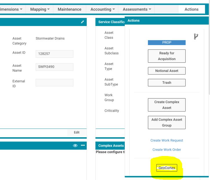
In the sample screenshot below clicking on the 'Action' button titled 'GeoCortex' will launch the GeoCortex GIS which will navigate to the currently viewed Stormwater asset.
Typical GIS Launch URL templates
The following templates are examples of how the System Connector may be used to launch each common GIS applications. These templates are configured in the "URL Template" form within the "System Connector" administration.
Once the template is defined, the 'context' for the template is configured on a per category basis in the "Context Configuration" form within the "System Connector" administration.
NOTE The following templates are examples only. Knowledge of the site GIS configuration is required to complete System Connector configuration. The GIS vendor may be required to assist since these are proprietary products, often with restricted documentation.
ArcGIS Online
For ArcGIS Online the following is a typical template:
http://XXX.maps.arcgis.com/home/webmap/viewer.html?webmap=[MapID]&search=true&find=[SearchValue]
| Parameter | Description |
| MapID |
The map ID defined by the webmap parameter in the URL is the ArcGIS Online map ID. In this example it would be set as a "Constant" parameter in the Context Configuration to cater for different maps based on context. If there is only ever one MapID then the include the MapID value in the template instead of using a parameter. |
| SearchValue | ArcGIS Online will search for this value in all searchable layers. This sample URL uses the ArcGIS Online Find parameter (ArcGIS Online Map Parameters). Within ArcGIS Online the field that the search value parameter translates to much be set as a searchable field in the ArcGIS Online map. For further detail refer to Configure Feature Search |
ArcGIS Server
For ArcGIS Server the following is a typical template:
http://www.arcgis.com/home/webmap/viewer.html?url=http://XXX.com/ArcGIS rest services/Demographics/ESRI_Census_USA/MapServer&source=sd&find=[Search]
| Parameter | Description |
| SearchValue | ArcGIS Online will search for this value in all searchable layers. This example uses the REST services published by ArcGIS for Server and the webmap provided by ArcGIS.com |
Spectrum Spatial Analyst (MapInfo)
For MapInfo Spectrum Spatial Analyst (SSA) the following is a typical template:
https://XXX.com/connect/analyst/mobile/#/main?mapcfg=[mapname]&queryTable=[tablename]&queryColumn=[columnname]&queryValues=[values]
- Replace XXX.com with the name of your map server.
| Parameter | Description |
| mapname |
The name of the SSA map to open |
| tablename | The name of the table to search |
| columnname | The name of the table column (field) to search. |
| values | The search value for the above configured table and column. |
The following link is an example of a completed URL (when SSA is launched by the System Connector) for a Bridge asset with Asset ID = "BR000149"
IntraMaps
IntraMaps supports "Parameter Passing" which enables IntraMaps to be started and display the current asset in Assetic. The GIS Administrator should be consulted to ensure the settings below are correct.
For IntraMaps the following is a typical "Parameter Passing" template (where the intramaps server is 'gis'):
http://gis/intramaps80/default.htm?project=[mapProject]&module=[mapmodule]&layer=[searchLayer]&mapkey=[searchKey]
In some instances the configuration below may be required. In this example the server is not locally hosted and has multiple IntraMaps configurations, hence the inclusion of 'configId':
http://gis.com/intramaps80/?configId=[configGUID]&project=[mapProject]&module=[mapmodule]&layer=[searchLayer]&mapkey=[searchKey]
| Parameter | Description |
| mapProject | The name of the map project e.g. "Assets". Defined in the IntraMaps 'ConfigManager' under the 'Project' tab. |
| mapmodule | The map module. Defined in the IntraMaps 'ConfigManager' under the 'Project' tab, expand the target project to list the 'Modules'. |
| searchLayer | Search layer e.g "Roads". This is the IntraMaps 'Layer Alias' of the 'Selection Layer'. In the IntraMaps 'ConfigManager' under the 'Project' tab choose the 'Project' and 'Module' within the Project. The 'Selection' option will list the selection layers, including the 'Layer Alias'. |
| searchKey | ID to search on, such as the asset ID. The 'mapkey' is a specific field in the selection layer. In the IntraMaps 'ConfigManager' under the 'Spatial' tab choose the 'Default Catalogue'->'Selection Layers' menu and then choose the layer. The 'Mapkey' field is defined, along with table name and layer name. |
| configGUID | a GUID identifying the Intramaps configuration (not usually required) |
Geocortex (Silverlight version)
For the Geocortex version that uses Silverlight the following is a typical template:
http://XXX.com/SilverlightViewer/?Viewer=Public&AttributeSearch=[Search],[SearchField],[ExternalID]
- Replace XXX.com with the name of your map server
| Parameter | Description |
| Search |
This is the name of the user defined search configured in GeoCortex. |
| SearchField | This is the field that will be searched. This search field is defined in Geocortex in the user defined search defined by [Search] above. |
| ExternalID | The value to be searched for in the search field [SearchField] defined above |
Geocortex (HTML5 version)
For the Geocortex version that uses HTML5 the following is a typical template:
http://gis.XXX.com/Html5Viewer/Index.html?configBase=http://gis.XXX.com/Geocortex/Essentials/REST/sites/ACMaps/Resources/Config/Default
- Replace XXX.com with the name of your map server.
The GeoCortex HTML5 viewer uses a startup "Workflow" that can be configured to search based on parameters supplied in the URL.
